

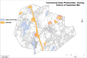
The Commercial Solar Photovoltaic Overlay District map that the Planning Board voted to send to Town Meeting consists of the properties above minus the three parcels circled in red.
At its Monday night meeting the Planning Board voted on a Commercial Solar Photovoltaic Overlay District map that it plans to send to Town Meeting voters, acting to limit commercial solar in residential areas and where deforestation is necessary. The map is limited to land along Interstate 495, the E.L. Harvey property at the border with Westborough, and three parcels that already have solar arrays installed on them.
The board voted 7-1 to accept the map and submit it to the town clerk, with Jane Moran voting no. Frank D’Urso was absent.
“At this moment in time this is the overlay district that we’re sending forward for Town Meeting consideration,” chair Muriel Kramer stated after the vote, which only addresses commercial ground-mounted solar. Rooftop solar (residential or commercial) is not affected.
Moran expressed a desire to be less concerned about narrowing the available land options and instead focus on controlling other factors related to solar projects, such as steepness of the grading as well as screening to minimize the impact on neighbors.
“How can we balance the personal property rights of individual landowners vs. being sensitive to neighboring residents?” she asked. “I believe there’s a way we can do it.”
Moran said solar might be a better option in the long run, even in residential areas. That opinion had support from some property owners who spoke at the meeting.
“If people aren’t going to be able to put solar on their property then it’s going to force something else, whether that be houses or office buildings or some kind of development,” property owner/developer Craig Nation said. “I suspect they’re looking to get something out of their land and they’ll do something with it, and it might not be as nice as solar fields, depending on the location. I agree that they don’t [belong] everywhere, but I just wanted to caution [about] the unintended consequences.”
The board used the map that appears at the top of this post — created by the Zoning Advisory Committee and originally shown at a Planning Board meeting in January — but voted to remove three parcels (circled in red): one at the I-495 interchange, one located off Frankland Road and one off Wilson Street. The Frankland Road and Wilson Street parcels already are planned for solar arrays, but Kramer previously explained that removing them would add some protection if the current developers decided to pull out of the projects — meaning a potential different future owner would not have the same grandfathered opportunity.
The votes on removing the three parcels also were 7-1, with Moran the sole no voter.
Owners of some other properties had requested to be included on the map but all were denied in Monday votes. Those parcels include the Chirco property off Nancy Lane/Teresa Road (parcel R30 20 0) — which abuts lands where the same owner already has a solar array that has drawn the ire of neighbors on Alexander Road — the adjoining Danahy property off Nancy Lane/Teresa Road (R23 102 0), and three properties owned by the Nation family that are located along I-495 South between Wood Street and Valleywood Road (U14 28 0, R17 1 0, and R17 3 0).
Once again those votes were 7-1, with Moran the only one voting to include the parcels.
Town-owned land at 66 and 66B Fruit Street (off the access road to the Fruit Street athletic fields) was kept off the map as well. That vote was 6-2, with Amy Ritterbusch joining Moran in voting in the minority.
The continuation of a public hearing on the Seaboard Solar project off Frankland Road had been scheduled for Monday as well, but it was pushed back to the next Planning Board meeting on June 22.
Town Meeting is expected to be held in September — after twice being postponed this spring due to the COVID-19 pandemic — but a date has not yet been finalized. If it gets pushed back again, or if the Select Board decides to hold only an abbreviated Town Meeting to address financial issues, Kramer noted that there is a possibility the map could be amended again.


0 Comments